APP Development
2022
Main goals/point of discussion
01
Identification of water issues
02
bringing people closer to ICTs
03
Involving the local community
04
3D Qualitative survey
Participants
Dr. Rania Aburamadan
Applied Sciences Private University

Dr. Victoria Cotella
University of Naples Federico II

Eng. Qasem Al-Betar
SurveyTEQ

Dr. Claudia Trillo
Bradford University
Dr. Angelo Lorusso
University of Salerno
Eng. Qais Hamarneh
Researcher
Outputs
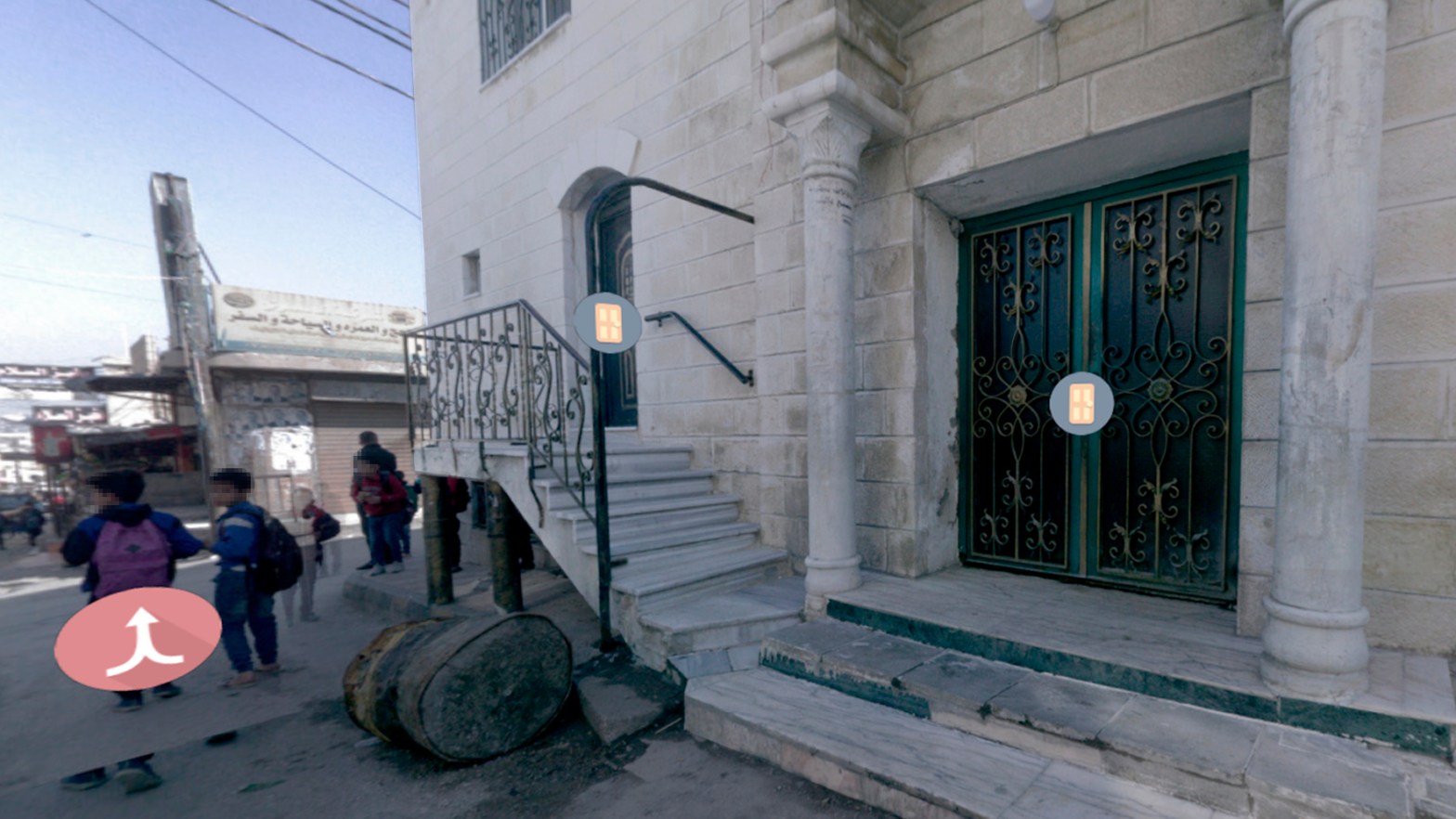
- The application always starts on the same starting point, and the user has to keep on navigating and pressing on the red arrow icon until the desired location is reached. Users are prone to not being able to reach their location using that starting point as for example they usually walk in a path that is different from the scanned street.
- The initial anticipated methodology of filling the water surveys was to let the people of the target area/ street themselves fill in the survey using their own devices or smart phones.
- It is not guaranteed that all local community members have a smart phone or device that can give them access to the app.
- It is not guaranteed that the surveys are filled by the corresponding people; a survey might have multiple entries where the entity responsible of gathering the information would not know which survey is the correct one.
- The application itself is not user-friendly, especially when trying to rotate the screen in order to find the door or when trying to go back in the scanned map.
Possible improvements to the app
- Instead of pressing on a link that directs users to website, one improvement can be is having an actual application that can be downloaded from the Appstore/google store on the phone directly.
- It is important to ease the access of people to the application in terms of time, access to the survey, access to location, and data entry. People in Baqa’a and Jordan in general are very familiar in using google maps (2D version) and in sharing their location via different applications such as WhatsApp.
- It is recommended that the Baqa’a app somehow can detect the location of the user (after having their consent of course). After detecting their location, the app can directly show them a pop-up survey for data collection and link their own survey to their exact location.
- To have a person or entity in-charge of the data collection is still a viable replacement. However, this person or entity should be someone that is trusted by the local community like the volunteers of the project
Insights
- An important note on the perceptions of people; According to them they fully believe that the problem is not in identifying what their problems are (in terms of water, sanitation, and all aspects of life) as they and their responsible entities know that already. The problem is that they are not seeing any changes in the ground due to corruption, lack of finances, and the fact that they are often overlooked/undermined.
- The local community in Baqa’a are in general hesitant to participate or give information due to their frustration on the reality/existing infrastructure and living conditions, loss of hope that anything might be changed or improved, as well as their lack of trust to the current entities responsible of providing them services. However, when it was explained to them by the project’s volunteers that the survey is for a project being implemented by research entities, universities and a foreign donor entity, their perceptions and attitudes were more positive, and they had much higher willingness to provide information and participate. Nonetheless, they were still hesitant/unwilling to fill the survey using the app itself without any incentives.
Supporting Documents
Project founded by the Royal Academy of Engineering

2020-2023
